
HWind
Observation-based tropical cyclone data for real-time and historical events in the Atlantic, East Pacific, and Central Pacific Basins
Hurricane Ian: The challenge of getting insights into your business faster
Using Moody’s HWind as a trigger for parametric insurance contracts
Parametric insurance contracts for hurricanes offer the promise of quicker payouts and the ability to fill in coverage gaps from traditional insurance, enabling businesses to recover more quickly in the aftermath of an event.
Hurricane Ian: The challenge of getting insights into your business faster
Overview of Moody’s HWind
(Re)insurers, brokers, capital markets, government agencies, and academia rely on HWind products for real-time event preparation and response, the triggering of parametric insurance contracts, validation against experience, and research.
Stay ahead of the storm
Understand the range of potential losses across multiple forecast scenarios, capturing the uncertainty in how track and intensity will evolve.
Accurate hazard insights
Identify the maximum wind speed experienced at a location to quickly determine if parametric insurance has been triggered and inform claims adjustment.
Validate against history
Demonstrate example pay-outs for past storms and validate pricing for parametric insurance. Calibrate historical claims against hazard for internal views of risk.
HWind real-time analysis
Real-time tropical cyclone data leading up to, during, and following landfall.
Forecasting
5-day forecast track scenarios, footprints, and losses made available up to every 6-hours once an Atlantic tropical cyclone is named
Snapshots
Instantaneous views of the tropical cyclone track and hazard characteristics produced every 6 hours throughout the storm’s life cycle
Cumulative footprints
Wind field footprint produced on a rolling, cumulative basis every 6 hours over the lifetime of the storm, leveraging all preceding snapshot analyses
Post-event footprints
Full wind field footprint and track produced 1-3 days after landfall, based on expert review of all available data used during and after the event
Customer success

AXA Climate to use Moody’s HWind as a trigger metric for parametric insurance policies
…Data coming from independent reputable organizations like RMS HWind solutions…will allow us to structure innovative parametric covers and bring to our clients the best tailormade Tropical Cyclone coverage both in terms of price and claim settlement.
Amaury Dufetel
Head of Insurance, AXA Climate

Swiss Re CorSo makes parametric payouts to hospitality sector clients in Mexico
Swiss Re Corporate Solutions has paid claims to clients of its parametric STORM solution in Mexico after Hurricane Beryl made landfall in the Yucatan Peninsula earlier this month.

AXA Climate to use Moody’s HWind as a trigger metric for parametric insurance policies
…Data coming from independent reputable organizations like RMS HWind solutions…will allow us to structure innovative parametric covers and bring to our clients the best tailormade Tropical Cyclone coverage both in terms of price and claim settlement.
Amaury Dufetel
Head of Insurance, AXA Climate

Swiss Re CorSo makes parametric payouts to hospitality sector clients in Mexico
Swiss Re Corporate Solutions has paid claims to clients of its parametric STORM solution in Mexico after Hurricane Beryl made landfall in the Yucatan Peninsula earlier this month.

AXA Climate to use Moody’s HWind as a trigger metric for parametric insurance policies
…Data coming from independent reputable organizations like RMS HWind solutions…will allow us to structure innovative parametric covers and bring to our clients the best tailormade Tropical Cyclone coverage both in terms of price and claim settlement.
Amaury Dufetel
Head of Insurance, AXA Climate
HWind enhanced archive
A catalog of 25+ years of high-resolution images, snapshots, and footprints from historical hurricanes
Same HWind framework
Informed by the same underlying science as the HWind Real-Time Analysis offerings
Additional data
Incorporates new, revised, or reprocessed data sources and track information made available after the event
Reduced uncertainty
Informed by additional analysis iterations to match observational data and create the best representation of a storm’s track and hazard profile over time
Continuously growing
Library is updated annually as new data becomes available and new storms occur
Spotlight

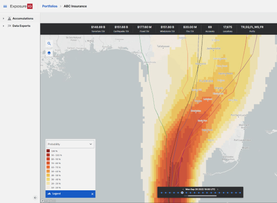
Release of HWind forecasting products (2019)
“Powered by a combination of HWind real-time observational data feeds, real-time track forecast data, and the RMS North Atlantic Hurricane modeling framework, our new forecasting products help the market gain earlier insights into potential hazard and loss impacts before landfall, informing key, time-critical decisions as the event unfolds."
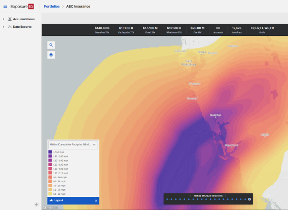
Real-time insights for fast parametric pay-outs
HWind cumulative footprints are finalized shortly after landfall enabling fast, reliable pay-outs of parametric insurance contracts. Typically based on observational data they can capture complex features in storm structure. Wind hazard is represented on a high resolution 1x1km grid enabling the wind speeds experienced at a location to be accurately identified, minimizing basis risk.
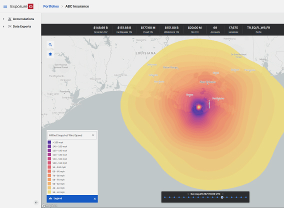
Unmatched scientific credibility
Backed by hundreds of citations in peer-reviewed publications across a variety of research fields, HWind data is used by researchers and scientists for numerous applications, including numerical weather prediction model validation, and as inputs for storm surge and wave models.

Release of HWind forecasting products (2019)
“Powered by a combination of HWind real-time observational data feeds, real-time track forecast data, and the RMS North Atlantic Hurricane modeling framework, our new forecasting products help the market gain earlier insights into potential hazard and loss impacts before landfall, informing key, time-critical decisions as the event unfolds."

Real-time insights for fast parametric pay-outs
HWind cumulative footprints are finalized shortly after landfall enabling fast, reliable pay-outs of parametric insurance contracts. Typically based on observational data they can capture complex features in storm structure. Wind hazard is represented on a high resolution 1x1km grid enabling the wind speeds experienced at a location to be accurately identified, minimizing basis risk.

Unmatched scientific credibility
Backed by hundreds of citations in peer-reviewed publications across a variety of research fields, HWind data is used by researchers and scientists for numerous applications, including numerical weather prediction model validation, and as inputs for storm surge and wave models.

Release of HWind forecasting products (2019)
“Powered by a combination of HWind real-time observational data feeds, real-time track forecast data, and the RMS North Atlantic Hurricane modeling framework, our new forecasting products help the market gain earlier insights into potential hazard and loss impacts before landfall, informing key, time-critical decisions as the event unfolds."
Related products

Cyclone, Hurricane, and Typhoon
Assess tropical cyclone risk to inform sound underwriting, portfolio management, and risk transfer decisions.

ExposureIQ
Proactively manage organization-wide risk concentrations and hot spots, access real-time risk analytics and event forecasting for rapid event response, and generate advanced portfolio insights, at scale.

Event Response Services
Predict the potential impact of active catastrophic events on your business with high-fidelity event response data delivered in real time.
Learn more

HWind legacy archive
RMS hosts a publicly-available legacy version of HWind archive data, which contains products from historical events through 2013, developed while HWind was a public entity under the National Oceanic and Atmospheric Administration. For more information on how to access this data, please click the link below.

Unrivaled insight and detail
HWind products reflect wind field characteristics with more frequency, accuracy, and granularity than publicly available sources, including the National Hurricane Center.
HWind datasets incorporate unique wind field analysis metrics developed by HWind scientists, such as Integrated Kinetic Energy, a globally recognized index for measuring tropical cyclone size and intensity, and a proven alternative to the Saffir-Simpson Scale.

Unparalleled suite of observational data sources
HWind incorporates the most comprehensive set of observational data sources in the market. The mix or private and public data feeds span more than thirty land, air, and sea-based platforms including aircraft reconnaissance, dropsondes, airborne Doppler radar wind measurements, buoys, satellites, and coastal observation networks. HWind also incorporates data from more than 10 types of deterministic and ensemble forecasting models.

HWind legacy archive
RMS hosts a publicly-available legacy version of HWind archive data, which contains products from historical events through 2013, developed while HWind was a public entity under the National Oceanic and Atmospheric Administration. For more information on how to access this data, please click the link below.

Unrivaled insight and detail
HWind products reflect wind field characteristics with more frequency, accuracy, and granularity than publicly available sources, including the National Hurricane Center.
HWind datasets incorporate unique wind field analysis metrics developed by HWind scientists, such as Integrated Kinetic Energy, a globally recognized index for measuring tropical cyclone size and intensity, and a proven alternative to the Saffir-Simpson Scale.

Unparalleled suite of observational data sources
HWind incorporates the most comprehensive set of observational data sources in the market. The mix or private and public data feeds span more than thirty land, air, and sea-based platforms including aircraft reconnaissance, dropsondes, airborne Doppler radar wind measurements, buoys, satellites, and coastal observation networks. HWind also incorporates data from more than 10 types of deterministic and ensemble forecasting models.

HWind legacy archive
RMS hosts a publicly-available legacy version of HWind archive data, which contains products from historical events through 2013, developed while HWind was a public entity under the National Oceanic and Atmospheric Administration. For more information on how to access this data, please click the link below.
Resources

Hurricane Ian Makes Final Landfall in South Carolina Accom...
As Hurricane Ian departed into the Atlantic from Florida’s east coast at 12:00 UTC (08:00 Eastern Time ET) Thursday, September 29, it then regained hurricane intensity later that day at 21:00 UTC (17:00 ET). It has made an unwelcome return; the National Hurricane Center (NHC) has announced that surface observations indicated that the center of Hurricane Ian made landfall on Friday, September 30, as a Category 1 hurricane at 14:05 ET (18:05 UTC) near Georgetown, South Carolina (pop, ~9,000). It had maximu...

Hurricane Ian: Strongest Hurricane in Southwest Florida Si...
The eighth named tropical storm of the current North Atlantic hurricane season, Major Hurricane Ian, made landfall as a Category 4 (Saffir-Simpson Hurricane Windscale) major hurricane near Cayo Costa, Florida at 19:05 UTC (15:05 Eastern Time ET) on Wednesday, September 28. Ian remerged into the southeast Gulf of Mexico after leaving Cuba as a Category 3 storm on Tuesday, September 27, and strengthened owing to warm sea surface temperatures and generally low vertical wind shear. It completed an eyewall replac...

Hurricane Ian: A Potential Category Five Hurricane?
A quiet North Atlantic hurricane season has certainly kicked into life, as Hurricane Ian approaches southwest Florida as a high-end Category 4 (Saffir-Simpson Hurricane Wind Scale – SSHWS) major hurricane. This is the ninth tropical storm of the current season and the fourth hurricane. Comparing this season to 2021, the ninth storm was Hurricane Ida in late August – and it was the most destructive of that year. Ian made landfall near La Coloma on the southwest coast of Cuba yesterday (September 27) as a Categ...

2022 North Atlantic Hurricane Season Halftime Report: The ...
With a few weeks to go until the North Atlantic Basin enters its most active period, now is a good time to recap recent activity, review updated seasonal forecasts, and look ahead to what may be in store for the remainder of the season. A Slow Start to the 2022 Season The North Atlantic Basin has been a little quiet since the start of the hurricane season. So far in 2022, the basin has not produced any hurricanes and just three tropical storms – Alex, Bonnie, and Colin: A tropical depression brought...

Exposure Management: Managing the Complexity of Estimating...
When a catastrophic event such as a hurricane or an earthquake strikes, an insurance business relies on the exposure management team to answer the big questions: What level of loss is the business looking at, how much will be recovered from our reinsurance, and how do we communicate this? In a recent blog for insurers, I looked at the importance of real-time event response and exposure management; in this blog, I will focus on reinsurance and the need to generate net loss figures. For most reinsurers, answeri...

What is Possible? Real-time Event Response
It is possible for a portfolio or exposure manager to get near-real-time information during a catastrophic event, so they can meet the decision-making and reporting needs of all their stakeholders.
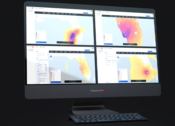
Moody’s RMS Event Response with HWind - Hurricane Ian
Moody’s RMS HWind produced more than 20 sets of forecasting products, snapshots, and cumulative footprints throughout Hurricane Ian’s lifecycle. Learn how HWind customers benefited from real-time insights before, during, and after landfall.

RMS HWind Hurricane Forecasting and Response and ExposureI...
Accessing data in real-time to assess and manage an insurance carrier’s potential liabilities from a loss event remains the holy grail for exposure management teams and is high on a business’ overall wish list A 2021 PwC Pulse Survey of U.S. risk management leaders found that risk executives are increasingly taking advantage of “tech solutions for real-time and automated processes, including dynamic risk monitoring (30 percent), new risk management tech solutions (25 percent), data analytics (24 percent) [and...

Hurricane Ian: The Challenge of Getting Insights into Your...
As soon as Tropical Storm Ian was named on September 26, 2022, our clients using the RMS® ExposureIQ™ application on the RMS Intelligent Risk Platform, have been accessing both our RMS Event Response event footprints and our RMS HWind real-time insights to provide a unique perspective on the progress of the storm. The ninth named tropical storm of the current North Atlantic hurricane season, Major Hurricane Ian made landfall as a Category 4 (Saffir-Simpson Hurricane Windscale) major hurricane near Cayo Costa,...

Hurricane Ian Makes Final Landfall in South Carolina Accom...
As Hurricane Ian departed into the Atlantic from Florida’s east coast at 12:00 UTC (08:00 Eastern Time ET) Thursday, September 29, it then regained hurricane intensity later that day at 21:00 UTC (17:00 ET). It has made an unwelcome return; the National Hurricane Center (NHC) has announced that surface observations indicated that the center of Hurricane Ian made landfall on Friday, September 30, as a Category 1 hurricane at 14:05 ET (18:05 UTC) near Georgetown, South Carolina (pop, ~9,000). It had maximu...

Hurricane Ian: Strongest Hurricane in Southwest Florida Si...
The eighth named tropical storm of the current North Atlantic hurricane season, Major Hurricane Ian, made landfall as a Category 4 (Saffir-Simpson Hurricane Windscale) major hurricane near Cayo Costa, Florida at 19:05 UTC (15:05 Eastern Time ET) on Wednesday, September 28. Ian remerged into the southeast Gulf of Mexico after leaving Cuba as a Category 3 storm on Tuesday, September 27, and strengthened owing to warm sea surface temperatures and generally low vertical wind shear. It completed an eyewall replac...

Hurricane Ian: A Potential Category Five Hurricane?
A quiet North Atlantic hurricane season has certainly kicked into life, as Hurricane Ian approaches southwest Florida as a high-end Category 4 (Saffir-Simpson Hurricane Wind Scale – SSHWS) major hurricane. This is the ninth tropical storm of the current season and the fourth hurricane. Comparing this season to 2021, the ninth storm was Hurricane Ida in late August – and it was the most destructive of that year. Ian made landfall near La Coloma on the southwest coast of Cuba yesterday (September 27) as a Categ...

2022 North Atlantic Hurricane Season Halftime Report: The ...
With a few weeks to go until the North Atlantic Basin enters its most active period, now is a good time to recap recent activity, review updated seasonal forecasts, and look ahead to what may be in store for the remainder of the season. A Slow Start to the 2022 Season The North Atlantic Basin has been a little quiet since the start of the hurricane season. So far in 2022, the basin has not produced any hurricanes and just three tropical storms – Alex, Bonnie, and Colin: A tropical depression brought...

Exposure Management: Managing the Complexity of Estimating...
When a catastrophic event such as a hurricane or an earthquake strikes, an insurance business relies on the exposure management team to answer the big questions: What level of loss is the business looking at, how much will be recovered from our reinsurance, and how do we communicate this? In a recent blog for insurers, I looked at the importance of real-time event response and exposure management; in this blog, I will focus on reinsurance and the need to generate net loss figures. For most reinsurers, answeri...

What is Possible? Real-time Event Response
It is possible for a portfolio or exposure manager to get near-real-time information during a catastrophic event, so they can meet the decision-making and reporting needs of all their stakeholders.

Moody’s RMS Event Response with HWind - Hurricane Ian
Moody’s RMS HWind produced more than 20 sets of forecasting products, snapshots, and cumulative footprints throughout Hurricane Ian’s lifecycle. Learn how HWind customers benefited from real-time insights before, during, and after landfall.

RMS HWind Hurricane Forecasting and Response and ExposureI...
Accessing data in real-time to assess and manage an insurance carrier’s potential liabilities from a loss event remains the holy grail for exposure management teams and is high on a business’ overall wish list A 2021 PwC Pulse Survey of U.S. risk management leaders found that risk executives are increasingly taking advantage of “tech solutions for real-time and automated processes, including dynamic risk monitoring (30 percent), new risk management tech solutions (25 percent), data analytics (24 percent) [and...

Hurricane Ian: The Challenge of Getting Insights into Your...
As soon as Tropical Storm Ian was named on September 26, 2022, our clients using the RMS® ExposureIQ™ application on the RMS Intelligent Risk Platform, have been accessing both our RMS Event Response event footprints and our RMS HWind real-time insights to provide a unique perspective on the progress of the storm. The ninth named tropical storm of the current North Atlantic hurricane season, Major Hurricane Ian made landfall as a Category 4 (Saffir-Simpson Hurricane Windscale) major hurricane near Cayo Costa,...

Hurricane Ian Makes Final Landfall in South Carolina Accom...
As Hurricane Ian departed into the Atlantic from Florida’s east coast at 12:00 UTC (08:00 Eastern Time ET) Thursday, September 29, it then regained hurricane intensity later that day at 21:00 UTC (17:00 ET). It has made an unwelcome return; the National Hurricane Center (NHC) has announced that surface observations indicated that the center of Hurricane Ian made landfall on Friday, September 30, as a Category 1 hurricane at 14:05 ET (18:05 UTC) near Georgetown, South Carolina (pop, ~9,000). It had maximu...

Hurricane Ian: Strongest Hurricane in Southwest Florida Si...
The eighth named tropical storm of the current North Atlantic hurricane season, Major Hurricane Ian, made landfall as a Category 4 (Saffir-Simpson Hurricane Windscale) major hurricane near Cayo Costa, Florida at 19:05 UTC (15:05 Eastern Time ET) on Wednesday, September 28. Ian remerged into the southeast Gulf of Mexico after leaving Cuba as a Category 3 storm on Tuesday, September 27, and strengthened owing to warm sea surface temperatures and generally low vertical wind shear. It completed an eyewall replac...

Hurricane Ian: A Potential Category Five Hurricane?
A quiet North Atlantic hurricane season has certainly kicked into life, as Hurricane Ian approaches southwest Florida as a high-end Category 4 (Saffir-Simpson Hurricane Wind Scale – SSHWS) major hurricane. This is the ninth tropical storm of the current season and the fourth hurricane. Comparing this season to 2021, the ninth storm was Hurricane Ida in late August – and it was the most destructive of that year. Ian made landfall near La Coloma on the southwest coast of Cuba yesterday (September 27) as a Categ...

2022 North Atlantic Hurricane Season Halftime Report: The ...
With a few weeks to go until the North Atlantic Basin enters its most active period, now is a good time to recap recent activity, review updated seasonal forecasts, and look ahead to what may be in store for the remainder of the season. A Slow Start to the 2022 Season The North Atlantic Basin has been a little quiet since the start of the hurricane season. So far in 2022, the basin has not produced any hurricanes and just three tropical storms – Alex, Bonnie, and Colin: A tropical depression brought...

Find the right HWind solution for your organization


